
Urban Data Portal Yemen
UN-Habitat //
About Urban Profiling
The impact of the conflict in Yemen is mainly urban. Even though key cities have faced different levels of destruction, secondary and tertiary cities have become ports for “reverse” population movement transforming them into hosting areas for IDPs. This influx is putting additional strain on existing services and infrastructure that are already scarce or depleted. In the context of a protracted crisis in Yemen, key challenges should be addressed pertaining to peace and stability. City Profiles are considered a means to address the risks and reality of the humanitarian crises, to mitigate impacts on the most vulnerable, including the displaced, and to enable affected people to determine the course of their futures. They represent an instrument for fostering recovery and contribute to stabilization and peace building by empowering urban communities, their leaders and members while in turn guiding investments and capacity building towards this objective.
Profiles developed with support of:


Cities we are
working in:
UN-Habitat has developed urban profiles in seven cities in Yemen. Furthermore, it has developed urban indicator dashboards giving a cross-sectoral comparison, based on secondary and remote sensing data.
Neighborhood data collection methodology:
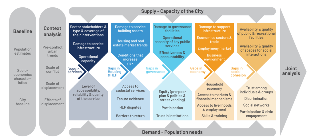
This urban profile describes and analyzes the situation in 7 cities in Yemen across a variety of sectors. Using an area-based approach, each individual section paints a separate picture through the latest available data. These are then synthesized to provide the most up-to-date holistic information backed by contextual information and analysis. The aim of the profile is twofold. First, it provides partners with the widest possible canvas to support future rehabilitation plans and prioritization of investments. Second, it assists them in their operational programming and strategic policy development. Urban profiling rests on different sets of elements and pillars, which jointly provide an integrated analysis that assess the city’s capacities as well as its population’s needs. The main elements of urban profiling – in bold – are discussed below:
1. Secondary Data Review
Secondary data draws on available publications and media to create a context-specific background of information on pre- and post- conflict trends and baselines, against which the full array of primary data is weighed. This provides a better understanding of focal events in the city’s own history, thus allowing the triangulation of analysis with primary data results.
2. Primary Data Collection Background contextual evidence and area analysis are insufficient material that do not fully capture individual and community experiences. Therefore, a series of structured interviews are conducted different stakeholders from a variety of fields to obtain both intersectoral and people-centered data.

Remote sensing:
With assistance of JRC and UNOSAT, damage assessments have been conducted through remote sensing. These damage assessment layers, and other layers developed in the urban profiling process, are available upon request. The link below gives access to the layer page.